View From Egypt to Chad in a larger map
 |
| The Bodele Depression. New research suggests that the Egyptians travelled to this area. Today it's an arid, dusty, low-lying area, but 4,000 years ago two lakes flourished here. Lake Bodele was about the size of modern day Lake Superior. An ancient version of Lake Chad also existed, albeit about the size of Lake Erie. Image courtesy NASA |
A trip across the desert of southwest Egypt is not for the faint of heart.
Modern day travellers departing southwest from the Dakhla Oasis will find themselves hitting their flasks as they traverse the Egyptian wilderness. Water sources are scarce, the area is sparsely populated and the lack of landmarks means you’ll want to keep your GPS system in good order.
Passing by Gilf Kebir, a plateau the size of Puerto Rico, you’ll find prehistoric cave paintings, evidence of a time when the climate was much more favourable to human life. Assuming you keep a southwest direction, and don’t get lost, you’ll come across a mountain range called Jebel Uweinat. Straddling the Egyptian-Libyan-Sudanese border, travellers will find springs there and – if you know where to look – a recently discovered 4,000 year old inscription, written in the name of Mentuhotep II, a pharaoh credited with reuniting Egypt.
If you continue southwest you’ll cross the border into southeast Libya and, if you keep on going, venture into the northeast corner of Chad, in Central Africa.
It’s a daunting, perilous, journey. And now, thanks to a body of new archaeological, textual, environmental and linguistic research, we have evidence that the ancient Egyptians undertook it.
In an article recently published in the Journal of Ancient Egyptian Interconnections, Thomas Schneider, a professor at the University of British Columbia, lays out this wide assortment of evidence.
“It’s something really new,” said Professor Schneider in a telephone interview. “There’s a new window opening into the past of Egypt.”
Follow the trail
One line of evidence, which suggests that Egyptians travelled to Chad, is found in the archaeology of the southwest desert.
“The Dakhla Oasis, situated some 300 km from the Nile Valley in Egypt’s Western Desert, can be regarded as the most southwesterly outpost of pharaonic civilisation,” writes Frank Förster in a British Museum article.
“in 1999 and 2000, the German desert traveller Carlo Bergmann found several sites which form a chain of staging posts on an almost straight line, the end of which lies close to the Gilf Kebir Plateau in the Libyan Desert, about 400km southwest of its starting-point in Dakhla.”
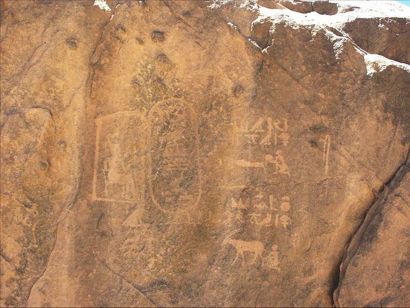
Or so he thought. In 2007 Mark Borda and Mahmoud Marai, a pair of explorers, found the 4,000 year-old Mentuhotep II inscription far to the southwest of Gilf Kebir at Jebel Uweinat. As mentioned earlier, this is a mountainous region on the borders of Egypt, Sudan and Libya.
Professor Schneider says that this is a significant discovery which shows that royal expeditions went much further southwest then Gilf Kebir. “At important places expeditions always left inscriptions,” he said. “I think it was also a demonstration that this is an official expedition trail set up by the Egyptian state.”
Schneider says that creating a trail that went from the Dakhla Oasis through the mountains of Jebel Uweinat would have been an incredible logistical feat. “You would have to establish way stations with water depots in the ground at specific places,” he said. “You would have to establish also these physical markers, these piles of stones, for example, that help you find the trail at certain distances.”
This would require lots of people. “You would have to mount an expedition with probably dozens of people, donkeys etc, all the equipment needed.”
Reaching Chad
Chad, unfortunately, is not an easy area for modern day archaeologists to work in. It is one of the most impoverished countries in the world and has faced years of civil war and strife. In 2008 armed rebel groups actually penetrated into N’Djamena, the country’s capital, before being repelled in a battle.
The country has also been experiencing climate change. Over the past few thousand years it has become more arid, with its northern half now being made up largely of desert.
With all these problems it is no surprise that archaeological evidence of the ancient trail ends at the border of Egypt, Libya and Sudan. But, even with a lack of on the ground archaeology, Schneider says that a case can still be made that ancient Egyptians reached the country.
He pointed out that 4,000 years ago Chad was an inviting place. If Mentuhotep’s expedition did reach the country they would have a found a land dominated not by desert, but by lakes, vegetation and wildlife.
Scientific studies published in the last few years show that there were two large lakes in the country. One of them, Lake Bodele, was a 91,000 square kilometre water body, making it larger than modern day Lake Superior. To the south there was Lake Chad, at that time a 22,000 square kilometre entity about the size of Lake Erie.
These bodies of water used to be even bigger, at one point they formed one large mega-lake. “At its peak sometime before 7000 years ago the lake was over 173 m deep with an area of at least 400 000 square kilometres, bigger than the Caspian Sea, the biggest lake on Earth today,” writes scientists Nick Drake and Charlie Bristow in a paper.
Land of lakes
It’s important to remember that the sun played a pivotal role in Egyptian religion. Every day it would rise in the east and set in the west. “The west for the Egyptians was always the underworld, also the realm of the dead,” said Schneider.
This can be seen in Egyptian burial traditions. “Most of the necropolises of Egypt were located in the west,” he said. “To some extent the Egyptians were aware that once they moved to the west they moved to the realm of the dead.”
Chad, being far to the west of Egypt, may have played a role in these traditions.
Professor Schneider has been investigating an ancient text called the Amduat, a “guide” of sorts that helped the king through the afterlife. Divided into 12 “hours,” complete examples of it were painted onto the walls of royal tombs 3,500 years ago. “It describes in a comprehensive way the topography of the underworld – a place that was unknown to the living Egyptians,” said Schneider.
He believes that some of those topographical references were inspired by actual places in ancient Chad. “Initially it is very down to earth with measurements, with descriptions.”
Schneider, in his paper, writes of one example, seen in the first hour, that, “Re gains access to the underworld through the ‘western portico (arry.t) of the horizon,’ a passageway of 1,260 km,” a pretty exact number for a mystical place.
“If this number has any factual basis, it could be seen as the distance between the oasis of Dakhlah [the start of the trail] and the northern shore of Lake Bodele,” writes Schneider.
The second and third hours of the Amduat may also refer to Chad. The second hour tells of “a region dominated by a gigantic body of water that fills the entire hour, a sweet- water ocean that is the source of abundant vegetation on its shores,” writes Schneider. Another measurement is given here, the “gigantic lake with its surrounding lands is given the precise dimensions of 309 by 120 jtrw (3,245 km by 1,260 km).”
Intriguingly the text refers to the “green plants that are in the Wernes” and describes the underworld figures as “farmers of the Wernes.”
Schneider said that the word “Wernes” is important. It’s a word that does not appear to have an Egyptian etymology and its ancient pronunciation was wūd˘ỉ-ỉensəu, which is remarkably similar to fwodi-yezze-u, a word spoken in the Tubu language of Central Africa. It roughly means “waterway/lake of the sun.”
That isn’t the only language similarity between Egyptian and Tubu. Schneider said in his article that about 4,000 years ago the consonantal sequence of Apophis, a snake-like villain in Egyptian mythology, was d-r-p-p. “On that basis, an appropriate etymology is provided by the Tubu duro bu bu (which means) ‘very big snake.”
The third hour of the amduat tells of a second large lake albeit the same size as the one mentioned in the second hour (3,245 km by 1,260 km).
“This topographical structure of an intermediate realm stretching from the Nile Valley 1,260 km (120 jtrw of 10.5 km) to the West, and followed by two gigantic lakes, finds an exact match in the palaeo-environmental situation of the Western Desert and the Chad Basin around 2000 bce,” writes Schneider.
Contact
Professor Schneider says that when this mix of archaeological, environmental, textual and linguistic evidence is combined together it suggests that there was contact between ancient Egypt and Chad. Royal expeditions could have travelled from the Dakhla oasis, through the mountains of Jebel Uweinat and entered into Chad – a land that, 4,000 years ago, was a rich lake country.
This is “a route where not just physical commodities (but) also ideas, concepts could have entered Egypt,” said Schneider.
“Egyptian intellectual history needs to be at one point re-written,” he said. “There are influences from regions that we never believed, 10 years ago, that there might have been influence.”
The very 'recent' formation of the sahara desert
ReplyDeletehttp://www.gks.uk.com/Sahara_Desert_Chaos/
The relationship between ancient Egypt - and for that matter, Kerma and Kush - with sub-Saharan Africa is a realm of archaeology that really needs a lot more attention. It will undoubtedly unveil a great deal not only about the African-ness (or otherwise) of Egypt, but about the development of state-societies south of Egypt.
ReplyDeleteAs far as the "4,000 year old inscription" is concerned, it was published in July 2008 in "Sahara, Prehistory and History of the Sahara", p. 129, with translation and comments. Title of the paper, by Joseph Clayton, Aloisia De Trafford and Mark Borda, is "A Hieroglyphic Inscription found at Jebel Uweinat mentioning Yam and Tekhebet". See www.saharajournal.com , Sahara volume 19, 2008.
ReplyDelete"Schneider said that the word “Wernes” is important. It’s a word that does not appear to have an Egyptian etymology and its ancient pronunciation was wūd˘ỉ-ỉensəu"
ReplyDeleteComments:
1. Excuse me but "Ur" is AE for "great". Ns can mean either "tongue" or "flame" depending on the determinative.
2. The rest of the theory of prof. Schneider is sounds very interesting.
Great theory about Duat as Sahara desert. Probably AE memory of Late Paleolithic/Early Neolithic exodus of the Sahara tribes towards Nile.
ReplyDeleteThe name Urnes is of exact AE origin at least from the time of the Middle Kingdom when the mentioned pharaoh Mentuhotep also ruled. Ur-nes means Great-flame and if prefer this theory for earthly origin of Duat should reminds of the heat started in Central Sahara around 9000 BC.
Egypt was part of a larger empire that split when the Sahara dried up. Mummies found in the Sahara were mummified using techniques that match the older Egyptian practices.
ReplyDeleteWhen we relieve ourselves of a colonial train of thought in regards to Egypt we will uncover a wealth of knowledge about human civilization that began long before Egypt.
supply evidence please
DeleteWhere did you find yours proving otherwise, liam? From who's lens was the evidence interpreted? Who decided where next to search for data and what type of connections were possible or to be made? How are entire areas of the continent on which Eqypt lies ignored in the understanding of its history, yet we only hear of European "influences" not the cultures/haplogroups surrounding and likely integrating into a bustling civilization. There's nothing more blind than an anthropologist/researcher/scientist of the "dominant" culture who has something to prove. It is not in their interest to find truth; they just require evidence supporting the dominance of their culture and because they have the luxury of "not humanizing" other "peoples", they have the luxury to pick and choose which evidence is highlighted to discount the "other peoples" as well.
DeleteIf the research were comprehensive and inclusive on your end, liam, maybe you wouldn't have to defensively hop on comment boards.
Not quite related to this discussion but I found several sites in Mauritania next to/at ancient lake beds huge deposits of pot shards, plates, bowles, grinding tools, some stone axes, stone knife fragments (I have a complete knife as well), human remains - people were obviously burried and over time the bones have become exposed as well as many other objects. Rock circles - posibly the foundations of some sort of structure or enclosure I found as well in the same area but it is difficult for me to say if they are as old as the rest of the finds. Small stones not from the area are present; these must have been traded and used to make sharp tools and are the same as in the National Geographic story "The Green Sahara". I wrote to them telling of my finds and offering to show them where to find the places but no reply. Surely someone is interested? Not even the Mauritanians were interested in these finds.
ReplyDeleteI am no longer in Mauritania but have the information of where these sites are. My e-mail is pmichael63@yahoo.com if anyone is interested.
Regards,
Paul.
nabta playa,recent discovery that ancient punt was in Eritrea-analysis of mummified baboon oxygen isotopes-so-called"black mummy",mega-cities in ancient southern Sahara etc.etc.
ReplyDeleteEnough already!Ancient Egypt was born a raised in Africa!and all this obfuscation about north Africa as opposed to"black Africa" is BULLSHIT.
There as never been a desert barrier of any real significance that impeded human beings particularly in ancient times.
Lakes become deserts: The story of Lake Chad https://www.patriotdirect.org/lakes-become-deserts-the-story-of-lake-chad/
ReplyDelete